Israel Trail Days 40 and 41: Sde Boker to Makhtesh Ramon
 Day 40: May 4, 2014
Wikiloc Map: Sde Boker to Ein Shaviv
Day 41: May 5, 2014
Wikiloc Map: Ein Shaviv to Makhtesh Ramon
Day 40 Mileage: 12.8 (21km)
Day 41 Mileage: 17.2 (27.7km)
Total distance since Tel Dan: 521 miles / 840km
These two days on the trail were the first time I did an overnight on the trail – the first time with a full backpack. In fact, it’s the first time I ever went backpacking.
It was a “learning experience.” My planning was insufficient – I’m not pleased with that, but I’m not going to hide what I did wrong. Maybe sharing my errors will allow someone else to learn from mine. If nothing else, writing it down will reinforce the lessons for me!
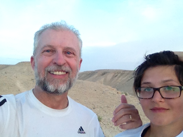
My daughter Katherine came along with me. We ended up finishing our hike about 10km short of our goal – because of a combination of unseasonably hot weather and poor planning. If the weather had been better, we could have gotten away with the planning sloppiness. If I had planned better, we could have handled the weather. But the combination of the weather and the planning led to some discomfort and the need to bail 10km early.
One thing I did right: getting a good backpack. My wife had found an abandoned backpack by a dumpster, and at first I thought I’d just use that. I loaded it up with the full load, about 45 pounds with two days’ worth of water, and it seemed OK, except my neck and shoulders really hurt. I did some research online, and found that with an overnight backpack about 80% of the weight should be on your hips – only 20% on your shoulders. The hip strap wasn’t holding, so consequently my hips weren’t taking much of the load, it was almost all on my shoulders. I decided that wasn’t a good idea, so I went and invested the NIS 1000 ($300) in a good backpack. I was REALLY glad I did. It was so much more comfortable – no comparison. Katherine borrowed a backpack from a friend.
It’s 55km from Sde Boker to Mitspe Ramon. Two long hard days if you have a full backpack. No water sources in between, so there are two choices: carry two days of water, or pay someone with a jeep to drive out and stash some water for you at the location of the camp for the night on the trail. I vacillated about whether to pay to stash water or not. After experimenting with the pack at different weights, I decided we could handle carrying what I thought would be enough water to two days – 11 liters each (4 liters water, liter and a half Gatorade). That was the first “planning mistake.” Your first time with a backpack, don’t plan to carry a double load of water, especially when it’s a long and hilly day. We would have been much better off carrying a more modest amount of water, but enough to give us some “extra,” say 7 liters, and have another 6 liters stashed for us.
Sunday morning I had some work stuff I wanted to finish before hitting the trail, so it was around 8am by the time we got out the door – about an hour and a half later than what I originally had in mind. I decided I’d make it a little easier for us by dropping Katherine and the backpacks off as close to the trail head as I could, which meant some driving back and forth with the car. I got her dropped off and the car parked at Sde Boker by 10; jogged 5km without a backpack to where she was waiting. It was about 11am by the time we got started, and the day was heating up considerably. This was the second planning mistake – if you have a long way to go with a full backpack, get an early start. We did the opposite of an early start.
After a very brief flat stretch, the trail heads straight up Hod Akev – 600’ climb in half a mile. The view at the top is awesome. But nothing stays flat for long, as soon as reaching the top we started down toward Ein Akev. Seven miles from Sde Boker we reached the spring, where we took a welcome lunch break and went for a very refreshing swim. The site was a little crowded – it’s easily accessible with a relatively short hike from a dirt road. There was a group of Norwegian tourists with a guide, a guy on a mountain bike, a couple of groups of Israelis.
Katherine’s shluker (water bag in the backpack) was empty already. Apparently she hadn’t filled it all the way to the top before leaving home, and she was sucking the water pretty fast because it was a hot day. Fortunately, some of the tourists had an extra bottle of water they gave her so we weren’t heading out low on water at the start of the trip already.
After our break, refreshed and recharged, we started our second climb of the day, this one more gradual than the first. After a couple of miles we reached a spot where the Israel Trail split: you can either take the “old trail” toward Ein Avdat, or the “new trail” toward Ein Shaviv. We took the new trail. Four miles from the spring we reached today’s summit at an elevation of about 2,000’. A steep descent of one mile brought us to Ein Shaviv. By this time it was starting to get late in the day. It was apparent to me that there was no way we were going to reach our goal of Nahash Tzame Night Camp before dark. We could either stop at Ein Shaviv, or keep going and stop somewhere along the way. We still had an hour and a half of light so we decided to keep going. I was reasonably confident we could get to the top where there would be flat places we could make camp before dark. Going through Ein Shaviv was interesting – lots of trees and greenery, it felt like we had arrived somewhere completely different from where we had been hiking.
We only made it about a mile past Ein Shaviv before I decided we should stop for the night while we still had some light instead of trying to push on to the dirt road at the top of the ridge.
Where we stopped the trail was working its way along the top of a narrow ridge, with drop-offs on both sides. We had a spot where it widened out a bit and was flat, but Katherine still didn’t like it – felt too much like you could roll over in your sleep and roll off a cliff. I pointed out it was a good 15 feet to the cliff edge and I’ve never seen someone roll that far in their sleep, but I understand the psychological thing of it somehow doesn’t feel “secure.” But I really wanted to stop to give us time to setup while it was still light.
We had covered 12.8 miles from Sde Boker. We were about 4 miles short of our goal for the day – 4 miles we would have had no problem covering if we had gotten out on the trail earlier. Hence the lesson about planning. Now we’d have to make up those 4 miles tomorrow. The good news is at least our packs would be lighter, and we’d for sure be getting an earlier start.
We set up camp, took physical inventory of our water (it looked OK – we had used about half), and made dinner. Rabbis for Human Rights had given me a nice camp coffee set when I finished my term as chair of RHR, specifically knowing I was doing the Israel Trail. I said a shehecheyanu blessing in honor of the first time using it and the first time I’ve carried my stuff and slept out on the trail. Dinner was crackers and spiced tuna and ramen noodles for me, Katherine had some buckwheat she brought, brownies for dessert.
I know my dinner was quite salty but that was partly intentional – with all the sweating we were doing I figured we needed to restore some salt to our systems. Probably didn’t need it, especially since we were also drinking some Gatorade, both for electrolytes and a quick boost of energy.
By 9pm we had stowed our gear and were in our sleeping bags looking up at the stars. The moon was out, and even though it was only a ¼ moon, it was very bright. I drifted off to sleep, but woke up in the middle of the night with my stomach feeling very uncomfortable. So uncomfortable in fact that after a few minutes I had to throw up and didn’t even have the energy to try and get away – I just leaned over as far away from my bag as I could and threw up my dinner. Not sure if there was something wrong with the food, or it was just too much salt, or what. My immediate thought was “what a waste of water!” Katherine was having visions of calling for a helicopter to evacuate us, but I knew better – I immediately felt MUCH better.
This time when I laid back down to go back to sleep the moon had set and the stars were absolutely unbelievable. I think it was more stars than I’ve ever seen, with the possible exception of one time when I was flying across the Arizona desert at night in a small plane and turned all my cockpit lights off. But it was truly stunning. Worth the “price of admission” for getting there. I managed to fall back asleep pretty quickly.
It wasn’t the most restful night. The ground was hard and I woke up a lot, but I fell back asleep each time. But we’d gotten into bed early enough that I felt pretty well rested when we woke up around 530.
We didn’t get out on the trail quite as early as I would have liked. By the time we got up, did our morning ablutions, made coffee, ate breakfast, repacked all our gear, etc., it was about 7am when we got started.
It was less than a mile to reach the dirt road at the top of the ridge. The road was very straight for quite a distance. It’s an access road for the gas pipeline from Eilat to Ashkelon. Right after seeing a sign warning not to dig because of the gas pipeline there was a sign warning you to go no further because of a military firing zone. I wonder if it occurred to anyone that putting a live fire zone next to a gas pipeline might not be a good idea??
After about 3 miles on the dirt road we reached Nahash Tzame night camp, which was our original destination for the previous night. Less than a mile further on was Hava night camp, where I was very disappointed to see a bunch of trash. I just don’t get how someone could love the outdoors enough to go to a place out in the middle of nowhere, only to leave a bunch of garbage. Just pisses me off.
From there we about a mile and a half of a “roller coaster” road, mostly down with some up until we arrived at another oasis, Wadi Hava (5 miles from our start in the morning). After a brief break we followed the trail up a canyon with some very dramatic views. The canyon was very narrow and deep – almost more like a wide crevice than a real canyon. After half a mile along the top of the canyon the trail made a fairly steep descent down into the canyon. Another mile or so further along we reached an intersection where those so inclined could continue up a dead-end canyon to another spring at Ein Hava. We decided to skip the extra distance since we already had additional distance to cover since we didn’t get as far as we wanted last night.
Coming up out of Nahal Hava was the only difficult ascent of the day, and it was quite a challenge. Even though in terms of elevation it wasn’t that bad – 800 feet in two miles – the terrain was VERY rugged. There were short bursts of vertical scrabbling up rocks followed by flat sections of hopping across boulders. Toward the end of the ascent the trail goes straight up a crevice. I decided to call this section “Spiderman Canyon.” We were doing some serious rock climbing in spots, and there were a few places where some of those metal handholds would have been very welcome – but they weren’t there.
We got to the top and caught our breath enjoying the wide open vistas, and then it was off again across one of those broad flat plains of flint. Only this time to make it even more fun the wind was blowing about 35 mph. I jammed my hat on as hard as I could and made a point of holding onto it during gusts. With the way the wind was blowing if I lost my hat it would have ended up in Jordan somewhere.
From the top it was only about two and a half miles to the turnoff for Meizad Mehmal, Mehmal Fortress. The fortress is a Roman-era ruin, on the old Nabatean “Spice Route,” overlooking Makhtesh Ramon, the largest of the three “craters” we passed. By this point in the day it was very hot and we were getting low on water. Katherine was really tired and decided to skip the half mile hike to the fort. When I got back to her we found a tree we could get under to get some shade. I laid down for a few minutes and suggested we take a longish break during the heat of the day and snooze, but the insects were too annoying for Katherine to get comfortable so we decided to keep going.
We took stock of our water supply, and it did not look good – we only had a few liters left each, and we still had about 12 miles to go to the finish, and it was a very hot day. I decided I’d call and have someone either bring us water or pick us up along the way. Only problem was we had no cell phone coverage. No problem, I told myself – we’ll be back to the edge of the crater within a couple of miles. Well, somewhat to my surprise, when we got to the edge of the crater I didn’t have any cell coverage! But when Katherine caught up with me we went just a little further and did finally get some cell coverage. I called an acquaintance in Mitspe, Ziv, and he offered to come out and get us.
Ziv said he didn’t have a jeep, but his car could manage the road to us. Right there the road didn’t look too bad, so I figured it must be like that all the way to Mitspe. Katherine and I decided to keep walking toward town instead of just sitting there. A short while later the road got really bad, and we said, “no way you could bring a regular car on this.” We hoped Ziv wasn’t going to have a problem, or that we’d soon get to a place where the road wasn’t as bad. It stayed pretty rough. But after about half an hour we saw a car coming our way. As we were walking Katherine started feeling better and said, “well, I could probably make it,” but by then it was too late, we’d already called. Ziv picked us up about 445pm, about 5 or 6 miles short of Mitspe. We would have had plenty of time to make it before dark if we’d had enough water. It was just as well we got picked up – we were low enough on water the last few miles could have been a little uncomfortable.
When I told Ziv that next time I’d have to get back to that spot for my start, he and Katherine got into a whole discussion about “what an American attitude!” An Israeli would have just said , “whatever,” and picked up with the next segment of the trail leaving Mitspe. But I’m bound and determined to cover every step of the trail under my own power, so even though it may be an “American” thing to do, next time I’m going back to where we left off.
Ziv is the owner of the Desert Shade Eco-Lodge in Mitspe, conveniently located right on the trail. We sat and visited with Ziv for a while, enjoying LOTS of cold water and some delicious melon. He gave us a ride to the bus stop, and we caught a bus back to Sde Boker, where I’d left the car. I would like to have visited with the mutual acquaintance by whose home we’d left the car, but she was in the middle of dinner, and we were eager to get back to Jerusalem for the Yom Haatzmaut celebrations, so we promised we’d meet up next time and hopped in the car and headed home.
It was quite a two days on the trail. I learned several important lessons about hiking in the desert with a full backpack.
I was reminded of something we flight instructors say about flying: when you first get your pilot’s license, you’re given two buckets: a full one of luck, and an empty one of experience. It’s of critical importance to fill your bucket of experience before you empty your bucket of luck. I used up some of my “luck bucket” for hiking in the desert on this trip. But I definitely added to the “experience” bucket!
“First time on the trail with a full overnight backpack.
Wikiloc Maps:
Day 40: http://www.wikiloc.com/wikiloc/view.do?id=6762138
Day 41: http://www.wikiloc.com/wikiloc/view.do?id=6776766”
From Israel Trail Days 40 and 41. Posted by Barry Leff on 5/07/2014 (50 items)

- At the start of Day 40, May 4, 2014


- It not only looks straight up, it is straight up.


- Yes, the trail goes straight into the brush.


- It looks like the trail goes in two different directions — one is the old trail, one…


- Was strange walking under all these trees in the middle of the desert.


- Katherine thinks these bumps are seeds. I don’t think so.


- At the end of Day 40. 20km (12.8 miles) with a 45 pound pack, and we didn’t get on th…


- Our camp.


- Rabbis for Human Rights gave me this nice coffee kit as a present when I finished my …


- Start of Day 41.


- Sign telling you not to dig — gas pipeline.


- Warning for a firing zone. Right next to the gas pipeline. Does it seem like that m…


- Road serving the gas pipeline from the Red to the Med… (sea to sea), Eilat to Ashke…


- "Thirsty Snake" (Nahash Tzame)


- This was an amazing canyon.


- If you look really close you can see Katherine at the base of the cliff — shows you …


- I call this "Spider-Man Canyon." Lots of going straight up and holding on …


- Yes, that’s the trail.


- Meizad Mehmal, an ancient Roman fort on the old Nabatean Spice Route, overlooking Mah…


- Our end of day picture — we got someone from Mitzpe to pick us up about 10km short o…

Generated by Facebook Photo Fetcher 2
(Israel Trail Days 40 and 41; 50 photos)
Pingback: Bamidbar 5774 – Finding God in the Wilderness | The Neshamah Center
Pingback: Israel Trail Day 42: Crossing Makhtesh Ramon to Gevanim | The Neshamah Center
Pingback: BeMidbar: Finding God in the Wilderness | Wellsprings of Wisdom