Israel Trail Day 51 Be’er Ora to Netafim
December 15, 2014
Wikiloc Maps: Part 1 Part 2
Distance: 32km
Total Distance since Tel Dan: 1109km (687 miles)
For logistical reasons, I decided to combine what Jacob Saar’s guidebook counts as two days into one day. Turned out to be one of the more difficult days I had on the trail, but it was a great day.
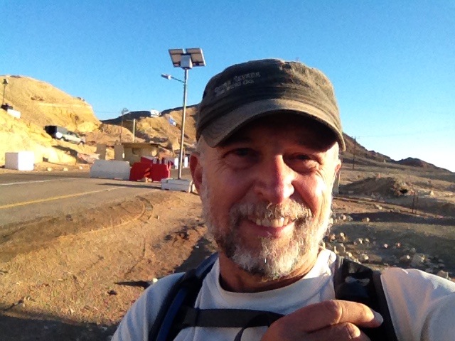
I drove down to Kibbutz Ketura on Sunday night, after some meetings in Tel Aviv. The room was fine, and the location convenient, but at NIS 350 it’s actually a lot more expensive than what you can find in Eilat on AirBnB. But it was comfortable and convenient. I knew it was going to be a long day; I got up at 0530, had breakfast, and was at the trailhead at Be’er Ora at 0630.
I was a little concerned about whether I’d have any problems from the oil spill. A week earlier, the largest environmental disaster in Israel’s history happened, right near Be’er Ora. An oil pipeline between Eilat and Ashdod breached, dumping 5 million liters of oil into a nature reserve. Fortunately for me, it was all on the other side of Highway 90 from where I was hiking. I never did see any of the oil, although I saw the heavy equipment involved in the cleanup operation, and at one point I smelled the oil.
32km was one of the longest days I had on the trail, and with almost 1200’ of climbing it had a fair amount of vertical for a long day. Some of it was also VERY rugged. The start was pretty easy though – about 13km of a steady climb up Wadi Raham. I was able to run all the way on this stretch, and was making good time. This early section was scenic, but what I now call the “standard wadi.”
By 9am, 13km in, I was at the upper end of Wadi Raham, which is where the fun began. This was one of the more challenging sections of the entire Israel Trail. Climbing up boulders without the help of any handholds. I have no idea why they put handholds in many other places, but didn’t put them in here. I have rotator cuff problems in both my shoulders and I found it quite challenging. Not sure what I would have done if I had a full backpack instead of a day pack. It would have been “interesting.” It was a good challenge though, and 15 minutes later I was at a little oasis, a few palm trees in the middle of the wadi. Made for a good spot for a break.
After a short break I was on my way again, and soon making my way up the Amram Ascent. At 10am I had what was for sure the most fun moment of the entire day: an amazing view of Eilat, Aqaba, and Red Sea. In the distance I could see Saudi Arabia. My goal was in sight. Another day and a half on the trail and I’d be on the beach in Eilat.
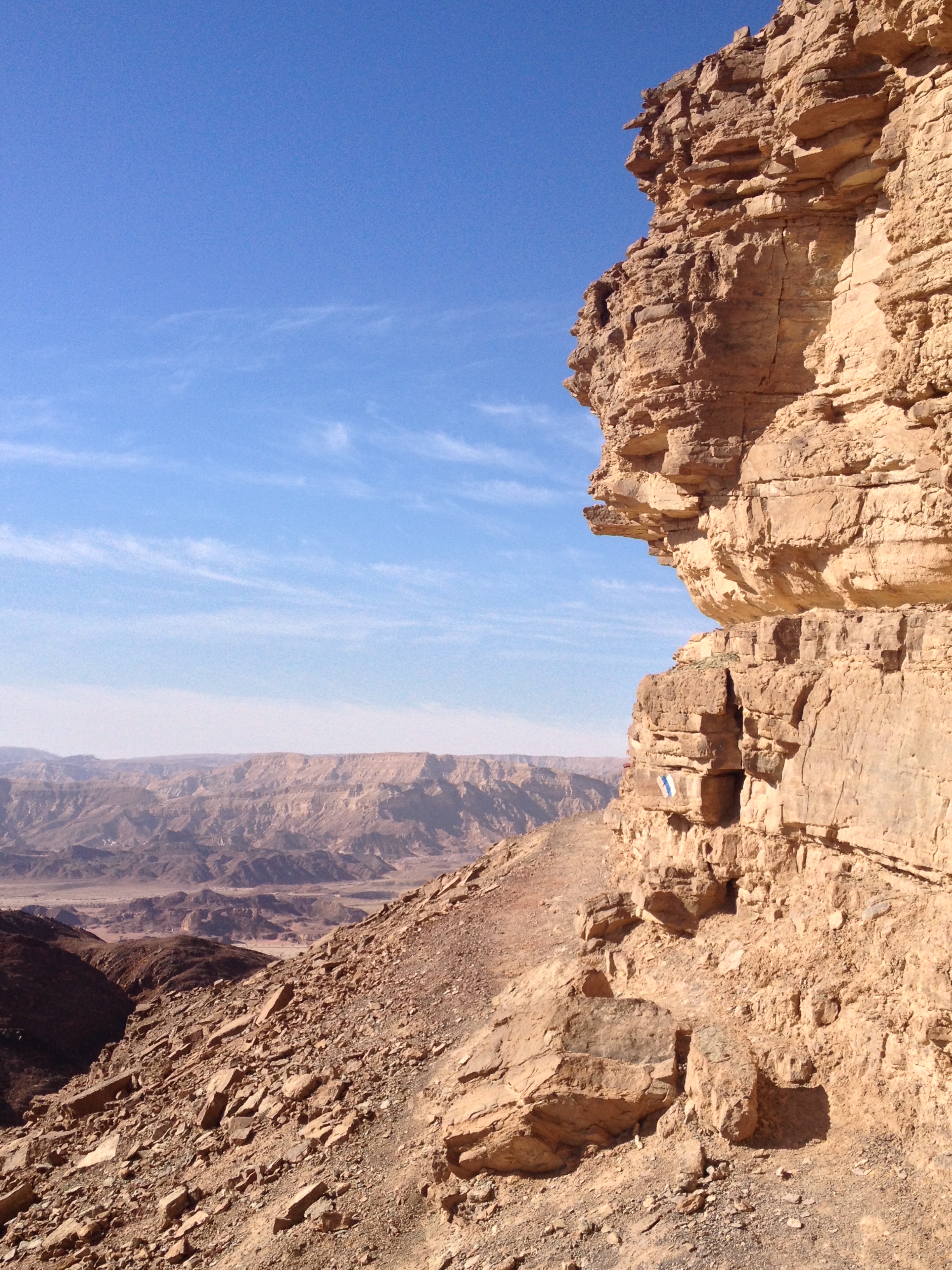
Coming down from Amram the trail goes next to some very impressive yellow sandstone cliffs. I would have liked to make the detour to Amram Pillars, but felt I wouldn’t have time. It was the right decision.
At 19km in the trail joined Nahal Shehoret. At 1120am I had completed 20km and was at the entrance to Shehoret Canyon – what the guidebook called a day on the trail. I was a little misled by the guidebook though: relative to the second “day” it said “after yesterday’s long hike, today it’s an easy one.” Well…it may have been only another 12km, but “easy” is not how I would describe it. The terrain was pretty rough in places and there was another “challenging” section. I didn’t finish until nearly 4pm. The “easy” day took me longer than the “long” day. It’s a good thing I had allowed plenty of time and started early. I had less than an hour of sunlight left when I got to the Highway 12.
Going up Shehoret Canyon was quite scenic – it would be a nice day trip. In fact there was a bus parked on the dirt road at the bottom of the canyon, so clearly it’s “accessible.” Didn’t see the people however.
After climbing out of the canyon for 4km I reached a turnoff for the “Lost Valley” at around 1pm. Part of the climb was rugged and steep. Even though I was a little concerned about time I decided to make the detour because it wasn’t very far off the trail, less than a kilometer. It was well worth the detour. Very pretty canyon, narrow walls with interesting shapes, similar to Wadi Barak, although smaller. It’s amazing how water can carve rock into such curvy sensuous structures.
After a short break in the canyon, it was back on the trail, now following Wadi Roded. After a couple of kilometers the trail intersected with Wadi Netafim. After another few kilometers of steady climb – 30km from the start – I reached Ein Netafim. Apparently it doesn’t take a lot of water to count as an “ein” (spring). There was a trickle of water and a few sprigs of green. Not much of an “oasis.” That trickle of water, however, is apparently the only year-round source of water in the Eilat Mountains. The spring was also a factor in deciding the border between the Ottoman and British Empires — and therefore the modern border between Israel and Egypt.
After a short pause, I was ready for my final challenge of the day. A very short, but straight up climb in a VERY narrow crevice. The guidebook says you have to take your pack off – I believe it. I managed to squeeze through with my daypack, but it was very tight and took some pushing. Would not have been fun for someone claustrophobic. I was debating how I would have managed it if I had a full backpack. With two people you could hand the packs up. With one person it would be tricky if you didn’t have a rope or something you could use to haul the pack up. By now it was 330, and I was hoping it wasn’t going to take too long to get to the road.
Fortunately, once I got to the top of the crevice, the tricky part was over. It was another easy couple of kilometers on a dirt road to Highway 12 at Netafim. I was now less than half a mile from the border with Egypt. I’ve pretty much covered the country from Lebanon to Egypt.
The trail comes out at a spot where there’s an IDF checkpoint. I presume that’s because heading northwest from the checkpoint Highway 12 goes right along the border with Egypt – and there has been a lot of unrest in Sinai lately.
At 4pm I was sitting by the checkpoint waiting for a cab to come pick me up and bring me back to my car. The cab ride took a little longer than it otherwise might have as we got stuck behind a bunch of runners carrying torches, some kind of Hanukkah thing. Half an hour and NIS 140 later I was back at Be’er Ora, in my car, and on my way home to Jerusalem. With just one single day left to complete the Israel Trail. As I write this, that day is slated to be the day after tomorrow. A few friends and two of my daughters are coming along on the last section, which should be fun. I’ll have a little bit of an “honor guard” for my last section.
“My next to the last day on the Israel Trail. Beautiful, strenuous day.
Wikiloc Maps (GPS stopped in the middle):
http://www.wikiloc.com/wikiloc/view.do?id=8450754
http://www.wikiloc.com/wikiloc/view.do?id=8450751”
From Israel Trail Day 51 Be’er Ora to Netafim. Posted by Barry Leff on 12/16/2014 (64 items)

- There were a lot of trucks going past the start of the trail — I later found out the…


- Wadi Raham


- That boulder is about ten feet high. Some handholds would have been very helpful.


- Diklei Raham, a small oasis. Nice spot for a break.


- My first view of Eilat, Aqaba, and the Red Sea from the Israel Trail. Was an excitin…


- This spot, the entrance to Shehoret Canyon, seemed in the middle of nowhere, but appa…


- The Lost Valley. Was well worth the 500m detour from the trail. Very cool rock form…


- Ein Netafim. Apparently it doesn’t take a lot of water to qualify as an "Ein&qu…


- The trail goes right up that narrow crevice. I barely made it with my daypack. With…


- This was really insane. One of the trickiest parts of the whole trail.


- There’s an IDF checkpoint at this spot on highway 12 because the road runs right next…


- Took a cab back to my car. We got stuck behind a bunch kids carrying torches. Looke…


Generated by Facebook Photo Fetcher 2
(Israel Trail Day 51 Be’er Ora to Netafim; 64 photos)