Israel Trail Days 6 and 7
March 15 and 17, 2013.
Wikiloc maps:
Day 6: Nahal Amud to Migdal
Day 7: Migdal Tiberias Ilit and Tiberias Ilit to Poriya Ilit
I completed the first “major” segment of the hike on this trip: from Tel Dan, in the far north on the border with Lebanon, to the Sea of Galilee. Next “destination” is Mt. Carmel near Haifa. I’ve completed about 75 miles on the trail, have about a similar distance to go until Mt Carmel.
For this leg I stayed at a B&B, D’vir Vacation Cabins, in Migdal. Was a comfortable place, a little pricey, but everything in the neighborhood seemed a little pricey. Room had a lovely view of the Arbel Cliffs, which was the first part of segment 8, the second of the two segments I did this trip.
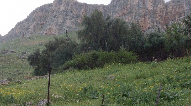
Segment 7 started near the Amud Junction, near where highways 85 and 65 meet. Was pretty easy for me to get a ride to 85/65 and I walked from there to the start. The hike through Nahal Amud was very scenic, although I think the upper part, on segment 6, was even a little more scenic. It was quite hot, about 90F. I was glad I was carrying plenty of water. Even with a lot of water I was feeling pretty hot by the time I finished half the trek — where there fortunately was a lovely spring was crisp, clear, cool water. VERY refreshing at that point. The lower part of the segment was somewhat less interesting, going through flat fields near the Sea of Galilee.
The trail itself doesn’t actually go all the way to the shores of the lake, so I added a hike on Saturday from my B&B to the boat museum at Ginosar so I could say I walked all the way to the Galilee.
Sunday morning it was only about a 1/2 mile walk to the start of segment 8, which was mostly pretty easy except for the climb up the Arbel. I had some light rain in the morning as I was starting out, but it quit pretty early. Lost the trail near the entrance to the Arbel, but it was open fields so easy enough to go “cross country” and re-connect with the trail using my GPS. The GPS is a VERY handy thing to have on this hike, it’s not always marked so well.
From the top of the Arbel the trail goes by Kfar Hittim and upper Tiberias. I accidentally didn’t restart my GPS recorder after a break, so segment 8 is split into two sections on Wikiloc. After Tiberias Ilit the trail goes throught the Swiss Forest, which was developed to help protect the area around Tiberias from mudslides. Funded by the Swiss Jewish community, hence the name. From the end of the segment at highway 7677 it was easy to get a ride down to the lake and a bus back to Migdal.
“see http://www.wikiloc.com/wikiloc/view.do?id=4119807 for segment 7; http://www.wikiloc.com/wikiloc/view.do?id=4132724 and http://www.wikiloc.com/wikiloc/view.do?id=4127854 for segment 8”
“see http://www.wikiloc.com/wikiloc/view.do?id=4119807 for segment 7; http://www.wikiloc.com/wikiloc/view.do?id=4132724 and http://www.wikiloc.com/wikiloc/view.do?id=4127854 for segment 8”
From Israel Trail Segments 7 and 8. Posted by Barry Leff on 3/17/2013 (64 items)

- At the start of Segment 7 of the Israel Trail, at Nahal Amud, near the junction of 85…


- I came around a corner and this cow was right in front of me. Not sure who was more …


- Have trouble seeing the trail? Me too. Ended up going cross country for a ways…th…


- Water pump station…pumping water from the Sea of Galilee to reservoirs uphill


- Description of the water system and pumps.


- "Amud" means pillar. This is the amud of Nahal Amud, the stream the trail …


- The temperature was 90F the day I made this run/hike…this spring appeared about hal…


- Approaching the Sea of Galilee…this segment completed the first major chunk of the …


- The end of Segment 7 at Migdal, across the street from the Sea of Galilee…about 70 …


- View of the Arbel from the B&B where I was staying


- Dvir’s Vacation Cabins in Migdal. Comfortable, good location, nice view of the Arbel…


- Beginning of segment 8 of the Israel Trail


- Segment 8 starts by climbing the Arbel. On this particular day, it also started with…


- Arab village of Hamam, near the base of the Arbel cliffs.


- This cow refused to budge off the trail. I talked to it, pleaded, no luck. I had to…


- If you look close you can see the handholds hammered into the rocks.


- View of Migdal from the Arbel


- At the top of the Arbel


- View of Tiberias from the Swiss Forest


- View of the Golan Heights from the Swiss Forest.


- I’ve seen lots of cows and sheep on the trail, not so many horses.


- Note the bird sitting on the sheep’s back.


- Near the exit from the Swiss Forest to road 7677, end of segment 8.

Generated by Facebook Photo Fetcher 2
(Israel Trail Segments 7 and 8; 64 photos)